|
|
Post by joemecca on Aug 30, 2013 19:02:30 GMT -5
google earth and its a 2011 image.
|
|
|
|
Post by jeffraz on Aug 30, 2013 19:14:22 GMT -5
Once we figure out what the specifics are it only makes sense that we become active to combat it. Is the name that Vince provided at the onset of this thread the guy we need to inform knowing what we know now?
|
|
|
|
Post by Vince Tobia on Aug 30, 2013 21:31:24 GMT -5
It seems as if these operations are not new, and have been going on at the same locations in prior years. I do not fish the Seneca Reservation as extensively as I used to, but I don't believe there were really any issues with these operations muddying up the stream in the past. I may be wrong however, and if they are in fact digging in the creek it would be worthwhile for anglers to contact William Miller from the Seneca Nation Conservation Department. Whether or not he would be able to help the situation is unknown to me, but it can't hurt to try.
If they are not digging in the creek then there is most likely nothing that can be done, and possibly no harm is being caused anyway.
|
|
|
|
Post by Chad Stevens on Sept 16, 2015 20:53:37 GMT -5
I did some scouting today on the Rez. Lots of gravel mining going on in the area with CP as its initials. It muddied up the water all the way downstream.
|
|
|
|
Post by mikereynolds on Sept 17, 2015 11:34:24 GMT -5
Is that gravel mining? I saw somewhere else it was shoreline stabilization. Weird time of the year to do stabilization work though.
|
|
|
|
Post by Chad Stevens on Sept 17, 2015 11:41:45 GMT -5
Is that gravel mining? I saw somewhere else it was shoreline stabilization. Weird time of the year to do stabilization work though. It is absolutely not shoreline stabilization. They are making two huge mounds of gravel in preparation for screening. They have a giant backhoe in the creek. They plunge it down 10 feet deep into the river and scoop out gravel and dump it into a dumptruck that has tires the size of a house, then the dumptruck drives up on top of the mounds and unloads it at the top. Soon they'll bring in the screening operation and sift through it all. This is not good. |
|
|
|
Post by MikeMurphy on Sept 17, 2015 12:05:19 GMT -5
I was exploring down there this morning at the CP area. They must have started the operation within the last couple of weeks. Definitely an area to avoid this fall. Company vehicles in the area were from Gernatt. This will give you some idea of the scope of the operation.  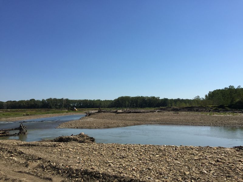  |
|
|
|
Post by mikereynolds on Sept 17, 2015 13:19:48 GMT -5
|
|
|
|
Post by johnbenish on Sept 17, 2015 13:22:08 GMT -5
I was down there thurs morning also, went through the cornfields, could not believe what I was seeing. Didn't think it was wise to get too close, but could see a huge ramp of dirt, very tall, I believe close enough to the water to really be a problem if it rains (as expected Saturday esp night). The water downstream from that point was still green but visibility not good. Also access at BD was not good, the creek has undercut the bank leaving about a 10 foot drop with little to tie a rope. Lots of silt in calmer places downstream. If we get more rain while the project is going on there might be trouble. I really hate to see such a mess on such a beautiful river. Looks like fishing this fall for me is going to mostly be on the area above the reservation.
A better note is that a couple of fish came out to play farther up, hit very aggressively.
|
|
|
|
Post by Chad Stevens on Sept 17, 2015 13:28:11 GMT -5
Maybe the plan is to perform bank restoration after they rape it for a few hundred thousand dollars of gravel???
Doubt it....
|
|