|
|
Post by Vince Tobia on Aug 29, 2013 15:08:39 GMT -5
I have heard some rumblings that there is digging going on in the creek bed on Cattaraugus Creek. I have not had a chance to scout the creek yet and see for myself.
Has anyone seen this firsthand recently?
If it is in fact happening and If we think it will be an issue with muddying up the Creek in the fall we may want to contact the Seneca nation of Indians.
If it is in fact happening I would suggest emailing William Miller from the SNI fish and game dept. to voice your concerns.
Will.Miller@sni.org
|
|
|
|
Post by NickConwall on Aug 29, 2013 17:06:34 GMT -5
...that & the fact that when they go gravel shopping like that they leave behind a nice clay bed for nothing to grow or live on.
-I know this is off topic but if you want to see a real heartbreaker take a look at what the river gold dredges are doing to the Amazon river & her trib's.
|
|
|
|
Post by johnbenish on Aug 30, 2013 5:42:52 GMT -5
Give me an idea which area, was out yesterday and didn't see activity, but probably was wrong area. Intersection of 20 and 5 is a real mess, river was not clear. I'll be back for more scouting soon.
|
|
|
|
Post by Vince Tobia on Aug 30, 2013 8:10:49 GMT -5
Are they building a new bridge at 5 & 20 John?
|
|
|
|
Post by ANDYCAMPING on Aug 30, 2013 8:31:34 GMT -5
Vince, Yes there is a new bridge going in there. The company I work for is involved in the foundation work and I've been to the site several times this summer. When I was there the DOT was doing a pretty good job of keeping the turbid water from returning to the creek, but I haven't been down there in August, so things may have changed.
|
|
|
|
Post by SteveKowalski on Aug 30, 2013 9:22:07 GMT -5
Andy,
is the new bridge down stream?, right next to? or in the same foot print?
I know they did a lot of reinforcing of the bank just up around the corner because most of it washed away, almost to rt 5/20
- there is no dirt road on the upstream side of the bridge any more.
|
|
|
|
Post by joemecca on Aug 30, 2013 12:50:39 GMT -5
the gravel mining operation is upstream of the rt 5& 20 bridge on the south bank
|
|
|
|
Post by Vince Tobia on Aug 30, 2013 14:30:54 GMT -5
Joe, approximately how far upstream from the 5 & 20 bridge?
If you have been there this year and have seen this personally, are they digging in the creek bed? or just on the banks?
|
|
|
|
Post by joemecca on Aug 30, 2013 15:33:47 GMT -5
Sorry i haven't been there recently. i believe its owned by gernatt. Its partially on chat county land and partial on reservation land. this one might not be the culprit but i've always suspected this one as the source of muddying up the creek down low. 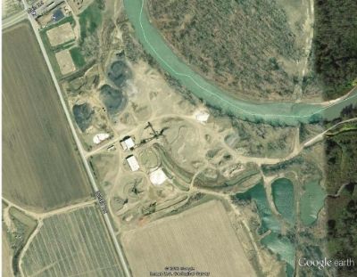 i also looked on google earth and it looks like there's a smaller one further upstream on reservation land. this one might be the one you're hearing rumblings about. its pretty damn close to the creek bed. if not it probably once was before they moved around the sediment. you can see the excavator and the dump truck on the aerial below. you can also see the "mined" area in the crappy red outline 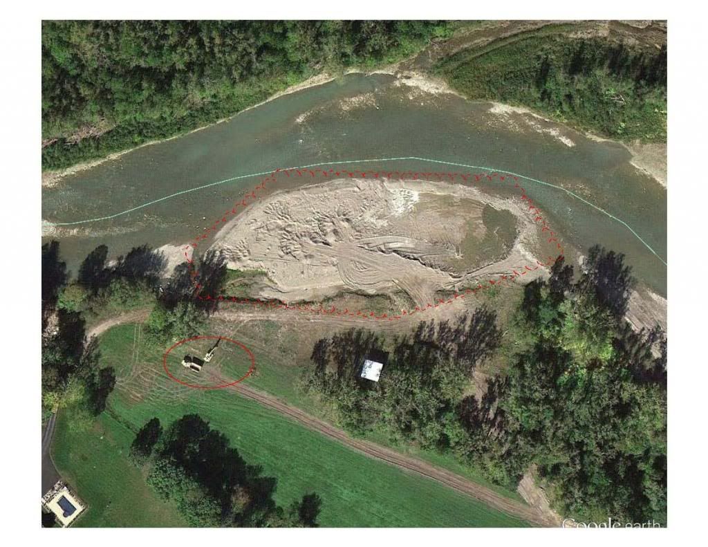 |
|
|
|
Post by Nick Pionessa on Aug 30, 2013 16:51:54 GMT -5
good info Joe. that second photo is the culprit. they have not worked on that one in a few years and if they are now it could muddy up a big portion of creek. what site is that image from? bing maps still shows it untouched and probably hasn't been updated for a year or so. here's how it looked last year binged.it/14eWZfd |
|